As urban populations grow and cities expand, traffic congestion and heat islands have become pressing concerns, especially in major cities like Jeddah, Dammam, and Riyadh in Saudi Arabia. While traffic management is often approached from a logistical and infrastructure standpoint, a less explored but equally vital aspect is the relationship between traffic flow and urban temperature. This is where the temperature mapping study plays a crucial role.
At Redlines, we specialize in conducting precise and actionable temperature mapping studies to support smarter urban planning, with a focus on both thermal efficiency and mobility. Our services are available across Saudi Arabia, including Jeddah, Dammam, and Riyadh. Visit our website at www.Redlines.sa for more information.
How Traffic Flow Influences Urban Heat
Vehicles are among the top contributors to urban heat due to engine emissions, surface heat accumulation, and frictional heating from tires. During peak traffic hours, congested roads act as heat reservoirs. This constant build-up of thermal energy results in micro heat islands that can significantly elevate localized temperatures.
Through temperature mapping study, experts can identify these heat-prone areas and analyze how traffic patterns contribute to increased temperatures over time. The goal is to correlate data such as road usage, vehicle density, and idle times with thermal changes.
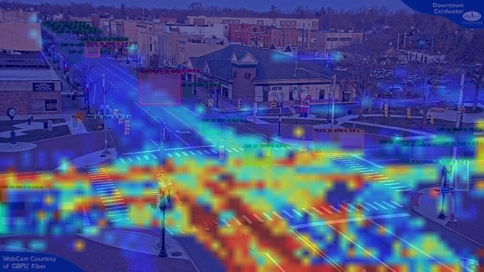
What is a Temperature Mapping Study?
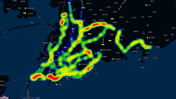
A temperature mapping study involves the collection and analysis of spatial and temporal temperature data. By deploying sensors across road networks and using remote sensing technology, Redlines gathers data on surface temperatures, ambient air temperatures, and real-time traffic flow. This data is then converted into heat maps, revealing hotspots and thermal trends throughout the day and week.
Benefits of Temperature Mapping in Traffic Management
- Informed Urban Design: By identifying areas with consistent thermal buildup due to traffic, urban planners can redesign road networks, optimize traffic signals, or introduce alternative routes.
- Cooling Solutions: In Riyadh and Dammam, where summer temperatures can soar, knowing where traffic-induced heat accumulates allows municipalities to install cooling pavements, plant trees, or use reflective materials.
- Improved Public Transport Planning: A temperature mapping study helps optimize bus stops, metro stations, and pedestrian crossings by placing them in cooler, safer zones.
- Reduced Emissions: Managing traffic more efficiently in hotspot zones also reduces fuel consumption and carbon output.
At Redlines, our advanced temperature mapping study solutions integrate traffic analysis tools to deliver holistic recommendations for municipalities and transport authorities.
Case Applications in Saudi Arabia
In Jeddah, a recent temperature mapping study conducted by Redlines revealed that certain coastal roadways retained heat even during evening hours due to heavy truck traffic. Recommendations were made to reroute commercial vehicles and add shaded pathways for pedestrian areas.
In Riyadh, the study helped identify intersections where high idling times significantly contributed to local heat spikes. Based on this, adaptive traffic signal systems were proposed to enhance flow and minimize heat impact.
Why Choose Redlines?
At Redlines, we understand the climate, culture, and infrastructure of Saudi cities. Our local expertise, combined with global knowledge, enables us to offer temperature mapping study services tailored to the unique needs of Jeddah, Dammam, and Riyadh. With our state-of-the-art technology and data-driven approach, we are helping cities become smarter, cooler, and more livable.
Learn more at www.Redlines.sa or contact us for a consultation.
Conclusion
The intersection of temperature mapping study and traffic flow is an emerging field with the potential to transform how cities in Saudi Arabia manage urban heat and mobility. As we plan for sustainable futures, understanding this relationship will be key in reducing heat stress, improving traffic efficiency, and enhancing the quality of life for residents.
Redlines is proud to lead the way in this innovation. Together, let’s build cooler cities with smarter movement.