As climate change accelerates and urbanization intensifies, heat islands—urban areas significantly warmer than their surrounding environments—have become a growing concern, especially in rapidly expanding cities like Jeddah, Dammam, Riyadh, and other parts of Saudi Arabia. Understanding and mitigating these heat islands is now a critical aspect of sustainable development. At the forefront of this mission lies an essential tool: the Temperature Mapping study.
At Redlines, we specialize in providing advanced Temperature Mapping studies that help cities and industries understand thermal behavior and create actionable strategies to manage heat buildup. Our services span across Saudi Arabia, with active operations in Jeddah, Dammam, Riyadh, and surrounding regions. Learn more about how we support sustainable development at www.Redlines.sa.
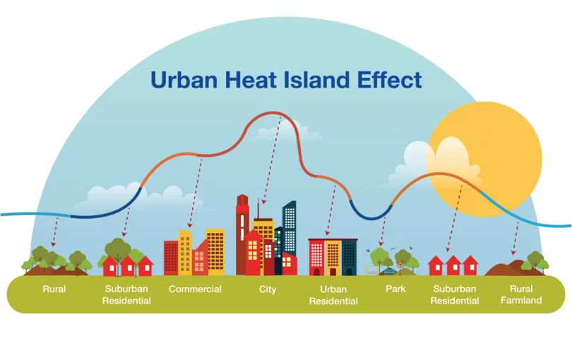
What Are Urban Heat Islands?
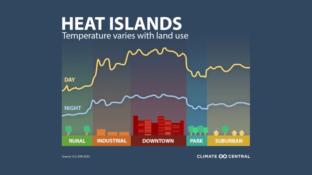
Urban heat islands (UHIs) form when natural land cover is replaced with dense concentrations of pavement, buildings, and other surfaces that absorb and retain heat. These surfaces store warmth during the day and release it slowly at night, keeping city centers significantly hotter than nearby rural areas.
The consequences are serious: increased energy consumption, elevated emissions of air pollutants, heat-related illnesses, and deteriorating quality of life—especially in densely populated regions like Riyadh and Dammam.
How Temperature Mapping Study Works
A Temperature Mapping study is a scientific process used to monitor, measure, and analyze temperature variations within a specific environment—be it a neighborhood, a building, or an entire city district. This study provides detailed spatial data that reveal temperature patterns, including hot spots, cool zones, and thermal flow.
At Redlines, our Temperature Mapping process typically involves:
- Site Survey – Understanding the geographical, architectural, and material conditions of the area.
- Sensor Deployment – Strategically placing calibrated temperature sensors in multiple locations to gather data at regular intervals.
- Data Collection – Recording temperature fluctuations over days or weeks, across varying times of day.
- Analysis & Visualization – Mapping the temperature data onto visuals such as heat maps to highlight areas with significant temperature differences.
- Reporting & Recommendations – Delivering comprehensive reports with actionable insights to help mitigate heat islands.
Temperature Mapping in Action: The Saudi Context
Cities like Jeddah and Dammam, due to their coastal nature, face combined challenges of humidity and heat, while Riyadh, located in the desert heartland, deals with dry and intense heat. Each city has unique urban thermal characteristics. That’s why a Temperature Mapping study must be tailored for each environment.
In recent projects across Saudi Arabia, Redlines has helped developers and municipal authorities:
- Identify high-risk zones for heat-related stress
- Plan green spaces and water features to reduce ambient temperatures
- Optimize building orientation and materials for passive cooling
- Improve energy efficiency in public infrastructure
Why Temperature Mapping is Essential for Urban Planning
Ignoring the temperature behavior of a built environment can lead to poor planning decisions. Urban projects without thermal foresight may unintentionally increase heat retention, resulting in discomfort and elevated operational costs.
With Temperature Mapping, planners and architects gain:
- Data-driven design insights
- Reduced cooling loads on HVAC systems
- Enhanced pedestrian comfort
- Long-term sustainability metrics
For example, a Temperature Mapping study in Riyadh helped reposition street layouts and introduced shaded pedestrian corridors that now record 3–5°C lower surface temperatures compared to surrounding areas.
Partner with Redlines for Smarter Cities
At Redlines, our mission is to empower cities and businesses with thermal intelligence that leads to more livable environments. Whether you’re planning a new residential district, upgrading public transport stations, or developing climate-resilient neighborhoods, our Temperature Mapping study can guide every critical decision.
We proudly offer our services throughout Saudi Arabia, including Jeddah, Dammam, and Riyadh, combining local knowledge with global expertise.
For consultations, case studies, and more, visit www.Redlines.sa.
Conclusion
As the urban heat island effect continues to rise, the importance of Temperature Mapping studies cannot be overstated. By revealing the hidden heat patterns in our environments, we can design cities that are not only cooler but smarter, healthier, and more sustainable for generations to come.