
As urban populations continue to grow and cities become more densely developed, the demand for sustainable and livable environments is greater than ever. One of the most pressing issues facing modern cities, especially in hot climates like Saudi Arabia, is the phenomenon of urban heat islands (UHIs) — areas within cities that experience significantly higher temperatures than their rural surroundings. A critical solution to understanding and addressing this problem is a temperature mapping study.
What Is a Temperature Mapping Study?
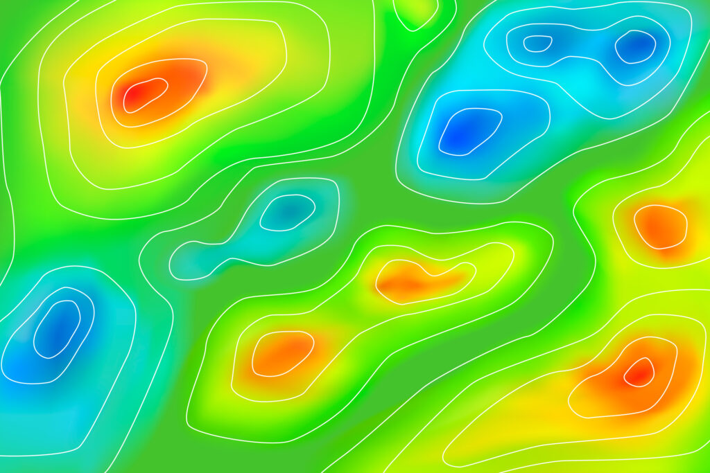
A temperature mapping study is a scientific and data-driven process used to identify, measure, and visualize temperature variations across different zones in an urban setting. By utilizing tools such as thermal imaging, sensors, drones, and geographic information systems (GIS), experts can collect valuable data that reveal how heat is distributed in cities like Riyadh, Jeddah, and Dammam.
At Redlines, we specialize in conducting advanced temperature mapping studies across Saudi Arabia. Our detailed approach ensures city planners, developers, and environmental authorities receive accurate insights to make informed decisions on urban development, public health, and climate resilience.
Why Is Temperature Mapping So Important?
Temperature mapping is not just a scientific exercise; it has real-world implications for quality of life, public health, infrastructure, and environmental sustainability.
- Urban Heat Island Effect Reduction:
Temperature mapping helps identify UHIs — areas where buildings, roads, and infrastructure absorb and re-emit the sun’s heat more than natural landscapes. By studying these patterns, cities like Jeddah and Dammam can implement targeted cooling strategies, such as increasing green spaces or using reflective materials in construction. - Improved City Planning:
With the help of temperature mapping studies, urban planners can design cities that are naturally cooler. This involves smarter layout of buildings, use of shading, and optimized airflow. Redlines provides expert guidance based on these studies to ensure your urban development projects are aligned with climate adaptation goals. - Energy Efficiency:
Knowing which parts of a city are hottest enables better planning for energy usage, particularly in cooling systems. Temperature mapping supports smarter HVAC system design, reducing electricity demand — a key concern in cities like Riyadh where temperatures can soar. - Health and Safety:
Prolonged exposure to high temperatures can increase the risk of heat-related illnesses. Temperature mapping studies help identify at-risk areas where vulnerable populations, such as the elderly or children, may need extra support. Redlines partners with health and municipal authorities in Saudi Arabia to provide actionable data for community well-being. - Disaster Preparedness and Climate Resilience:
In a world facing more extreme weather patterns, cities must be prepared. A well-executed temperature mapping study provides the baseline needed for long-term climate resilience planning. It allows cities like Dammam and Jeddah to future-proof their infrastructure and safeguard their populations.
The Redlines Process
At Redlines, we follow a robust and transparent process for temperature mapping:
- Initial Assessment: Understanding your city’s layout, challenges, and needs.
- Data Collection: Using cutting-edge sensors, drones, and satellite data to gather thermal information.
- Data Analysis: Applying GIS tools and data modeling to highlight hotspots and trends.
- Reporting & Strategy: Providing detailed reports and actionable solutions for urban cooling.
We have successfully delivered projects in Riyadh, Jeddah, Dammam, and other areas across Saudi Arabia, working with municipalities, private developers, and environmental agencies.
Partner with Redlines
Creating cooler cities isn’t a dream—it’s a necessity. With urban temperatures rising and energy demands escalating, a temperature mapping study is no longer optional; it’s essential.
Partner with Redlines, your trusted expert in temperature mapping across Saudi Arabia. Visit www.redlines.sa to learn more or contact our team for a consultation. Together, we can design a cooler, safer, and more sustainable urban future.