In hot climates like those found in Saudi Arabia, designing a transportation network that can withstand extreme temperatures is not just a matter of comfort — it’s a matter of safety, efficiency, and long-term durability. Cities such as Jeddah, Dammam, and Riyadh experience intense heat, which can affect road surfaces, rail systems, cargo safety, and even passenger comfort. One of the most effective strategies to address these challenges is conducting a comprehensive temperature mapping study to identify risk areas, predict potential damage, and optimize cooling and insulation strategies.
At Redlines, we specialize in providing temperature mapping study services in Saudi Arabia — particularly in Jeddah, Dammam, and Riyadh — to help businesses, logistics providers, and government agencies build and maintain transportation systems that are truly heat-resistant. Learn more at www.redlines.sa.
Why Temperature Mapping Study Matters in Heat-Resistant Transportation
A temperature mapping study involves collecting and analyzing data on how heat is distributed across different parts of a transportation system. This includes roads, bridges, train carriages, shipping containers, and even storage areas for transported goods. By identifying hotspots and understanding temperature variations, planners can implement design improvements and protective measures that prevent heat damage and extend the lifespan of infrastructure.
For example:
- Asphalt and road surfaces can soften or crack under high heat.
- Rail tracks can expand and warp, leading to safety hazards.
- Cargo containers without proper insulation may cause spoilage or product damage.
With a detailed temperature mapping study, these risks can be predicted and addressed before they become costly problems.
Applications of Temperature Mapping Study in Transportation
- Road and Highway Resilience
Using a temperature mapping study, engineers can identify the specific areas of a road network most exposed to intense heat and reinforce them with heat-resistant materials. - Railway Safety
Rail systems in cities like Riyadh and Dammam face the risk of track expansion during extreme heat waves. A temperature mapping study allows for timely adjustments and maintenance schedules that prevent disruptions. - Cargo Protection
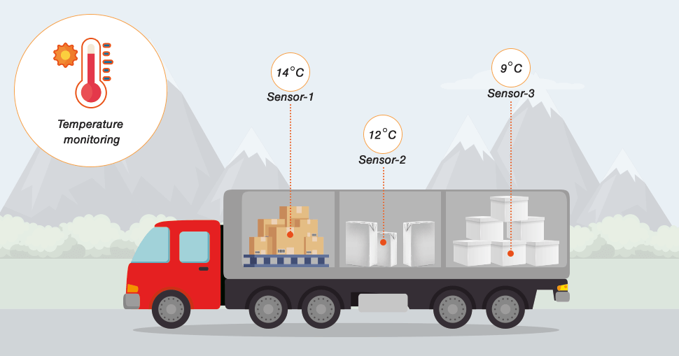
Heat-sensitive goods such as pharmaceuticals, electronics, and food products require strict temperature control during transit. A temperature mapping study ensures that transport vehicles and containers maintain safe internal temperatures, reducing product loss. - Public Transport Comfort
Passenger buses, metro systems, and trams can use temperature mapping study results to improve air conditioning efficiency and reduce energy consumption.
The Role of AI and Advanced Technology
At Redlines, we combine temperature mapping study with advanced analytics and AI to provide real-time monitoring and predictive modeling. This allows transportation managers to act quickly when temperatures rise above safe thresholds. Our services are designed for both new infrastructure projects and upgrades to existing networks.
Whether it’s integrating temperature sensors into vehicles, installing heat-resistant materials, or optimizing maintenance schedules, Redlines ensures every decision is backed by precise data.
Our Services in Saudi Arabia
We proudly offer temperature mapping study services throughout Saudi Arabia, with a strong presence in Jeddah, Dammam, and Riyadh. Our team works closely with government transport authorities, private logistics companies, and industrial clients to design transportation systems that can withstand the challenges of extreme heat.
Visit us at www.redlines.sa to learn how we can help your transportation projects remain reliable, efficient, and safe year-round.
Conclusion
As climate conditions become more extreme, building a heat-resistant transportation network is no longer optional — it’s essential. Conducting a temperature mapping study is the first step toward ensuring that roads, railways, and cargo systems are protected from heat damage.
With Redlines’ expertise in temperature mapping study across Saudi Arabia, including Jeddah, Dammam, and Riyadh, transportation planners and operators can make data-driven decisions that enhance safety, extend infrastructure lifespan, and reduce operational costs.
If you’re looking to create a resilient, future-ready transportation network, let Redlines be your trusted partner. Learn more at www.redlines.sa.