
In today’s era of climate-conscious development, understanding how heat behaves across urban landscapes is critical. As Saudi Arabia continues to expand and urbanize rapidly—particularly in key cities like Jeddah, Dammam, Riyadh, and others—planners are seeking smarter ways to design neighborhoods that balance comfort, energy efficiency, and sustainability. At the heart of this mission lies a powerful tool: the Temperature Mapping Study.
At Redlines, we specialize in conducting in-depth Temperature Mapping Studies that guide neighborhood planning across Saudi Arabia. Our expertise allows urban planners, architects, and developers to design communities that respond to environmental realities rather than work against them. Learn more about our services at www.Redlines.sa.
What Is a Temperature Mapping Study?
A Temperature Mapping Study is the systematic measurement and analysis of temperature variations across different spaces—indoor or outdoor—over a set time period. In the context of neighborhood planning, this includes mapping temperature fluctuations across streets, green spaces, building clusters, parking lots, and more.
By identifying hot spots, wind-blocked areas, poorly ventilated zones, and thermally stable regions, planners can make informed decisions about how to structure neighborhoods for optimal comfort and reduced energy consumption.

Why Neighborhood Temperature Mapping Matters
Urban heat islands (UHIs)—areas that experience significantly higher temperatures due to dense construction and lack of vegetation—are common in many Saudi cities. Through Temperature Mapping Studies, planners can:
- Identify and mitigate heat-prone areas
- Enhance walkability and livability
- Strategically place green spaces and shade structures
- Plan for efficient HVAC loads in residential zones
- Create better airflow and ventilation through road and building alignment
Whether it’s Riyadh’s scorching summers or Dammam’s coastal humidity, understanding the thermal characteristics of a space leads to better long-term infrastructure decisions.
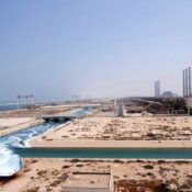
Real-World Applications in Saudi Cities
In Jeddah, we at Redlines have helped planners identify how reflected heat from large structures was impacting adjacent pedestrian areas. By modifying the orientation and introducing water features and shade elements, the microclimate was improved significantly.
In Dammam, our Temperature Mapping Study guided developers in planning new residential blocks with staggered building heights and optimized spacing, which allowed better air circulation and reduced overall daytime temperature buildup.
Meanwhile, in Riyadh, we supported smart city initiatives by integrating Temperature Mapping data with other environmental metrics to model energy-saving zones. These insights were used to tailor neighborhood designs that aligned with Vision 2030’s sustainability goals.
Variations in Temperature Mapping: A Key to Custom Solutions
No two neighborhoods are thermally identical. Differences in topography, building materials, traffic density, vegetation cover, and wind direction mean every Temperature Mapping Study must be site-specific.
At Redlines, our studies account for:
- Time-of-day variations (e.g., midday vs. early evening heat levels)
- Seasonal temperature differences
- Building orientation and material thermal retention
- Shadow patterns from neighboring structures
- Urban density and surface albedo (heat reflection)
By leveraging these variations, we don’t just provide generic heat maps—we deliver actionable intelligence that feeds directly into the urban design process.
Planning Smarter Neighborhoods with Redlines
Our mission at Redlines is to ensure that every new development in Saudi Arabia is built with thermal intelligence at its core. With our expertise in Temperature Mapping Studies, we equip planners and architects with the knowledge to build healthier, cooler, and more efficient neighborhoods—tailored to local climate conditions in Jeddah, Dammam, Riyadh, and beyond.
If your next project demands smarter neighborhood planning grounded in real-world thermal data, visit us at www.Redlines.sa or contact us today to book a consultation.
Conclusion
As cities grow and temperatures rise, Temperature Mapping Studies are no longer optional—they’re essential. By embracing this science-driven approach, Saudi Arabia can continue to build communities that are not only sustainable but also genuinely comfortable for generations to come. Let Redlines be your guide to future-ready neighborhood planning.